Integrating Digital Cave Maps in a GIS
Integrating cave maps into a GIS is often the ultimate goal in an evolving a cave and karst information system (CKIS). There's a variety of ways to approach this task, and the method chosen will depend on the desired results and the requirements of the implementation. The following screenshots present an overview of some options for integrating digital, scanned, and vectorized cave maps.
Click on a thumbnail to view a larger image. All maps and images by: B. W. Szukalski.
GEOLINKING MAPS
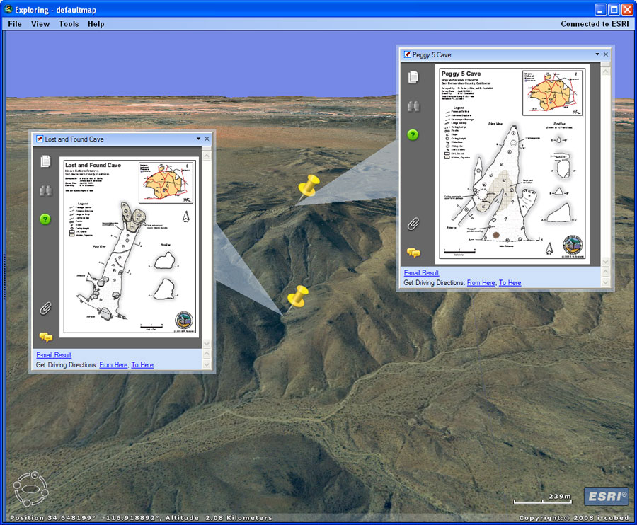
An easy, and easily maintainable, way to include cave maps in ArcGIS is to geolink them; attaching the maps as attributes or popups to GIS layers with the cave location. Here GPS data has been used to create point features of cave locations. Each point includes attributes to which the cave maps can be viewed by clicking on the feature. The cave maps were created using Macromedia FreeHand and Adobe Illustrator, and are saved as PDF files which are viewable as feature popups. ArcGIS Explorer is used to display the data.
An alternate approach, but requiring much more work, is to georeference the cave map. Scroll down this list to view an example.

GEOREFERENCED CAVE MAP SHEET
Though requiring considerably more effort, this technique allows the complete cave map to be brought into the GIS. Using Adobe Illustrator the layers containing survey stations and survey lines were toggle on, and the map was exported as a raster (TIF). The cave map could also have been scanned. The georeferenced survey stations and lines were exported from Compass as shapefiles. The features in the shapefiles were used with the survey data shown in the cave map layers to provide georeferencing links used in ArcGIS.
An alternative method is to export the artwork from Illustrator in either DXF or DWG, and georeference the output data (see example below). This eliminates the need to georeference the raster map, eliminates the page background, and still preserves all the drawing details. However for many implementations geolinking (see above) rather than georeferencing is the best method. And makes the most sense if the corresponding basemap data is of coarse resolution.
GEOREFERENCED CAVE MAP
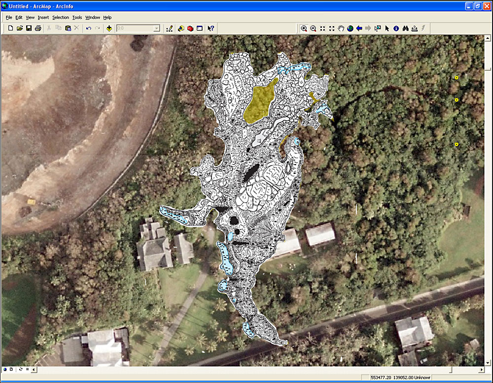
A detailed Macromedia Freehand (now replaced by Adobe Illustrator) map of Admiral's cave (by R. Richards) has been exported as a raster image and georeferenced using ArcView GIS. The map is shown over high-resolution aerial imagery obtained from the Bermuda Department of Planning. The detailed cave map can be used to show the relationship of surface features to features within the cave. The cave outline can also be digitized from the georeferenced map (see example below). This map was prepared as part of the ongoing Bermuda Cave and Karst Information System (BeCKIS) project.
The detailed cave map can be used to visualize the relationships of surface features to features within the cave. In this particular case the GIS was used to show that several cave pools with high fecal coliform levels were in close proximity to the sewage injection wells of nearby buildings.
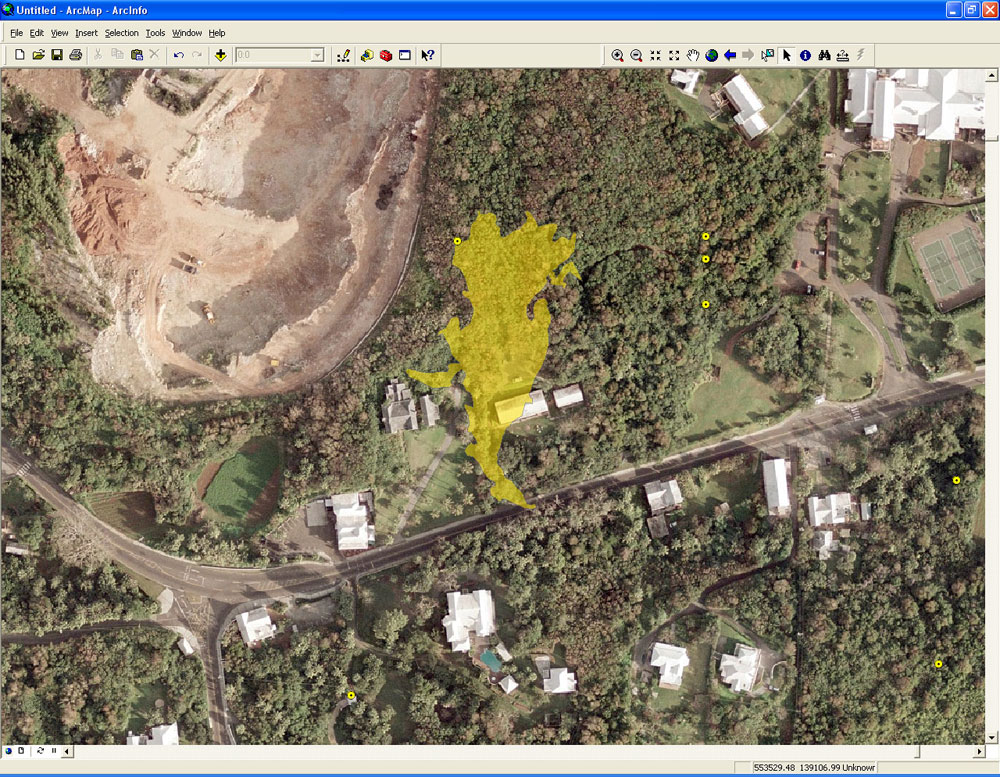
DIGITIZED CAVE OUTLINE
The outline of the cave has been digitized from the georeferenced cave map shown above. The outline uses partial transparency to allow underlying features in the aerial imagery to be seen. Additional karst features are shown as yellow dots.
An alternative and much easier method is to use Compass to create the passage wall outlines and export the outline as a shapefile or KML. Additional ArcGIS processing (such as using Dissolve) may be needed to create the desired result. Though providing generalized outlines, in many cases this is sufficient to meet the needes of the project at hand. In this case the high resolution imagery and the goals of the study merited this approach.
Yet another option is to export the cave passage outlines as DXF or DWG files (DWG files are preferred) directly from the map drafting software (e.g. FreeHand, Corel, Illustrator, Canvas). This provides the high accuracy outline, without the need for image georeferencing.

GEOREFERENCED MAP AND PASSAGE OUTLINES
In this example both a georeferenced cave map and the passage outline have been combined. The cave map has been exported as a raster from Illustrator and georeferenced. The passage outline (shown in yellow) has been created using Compass and exported as a shapefile. For the purpose of understanding general passage morphology and its relationship to surface features, the exported passage outlines are the easiest solution. In this particular case (a lava tube) the extra effort of georeferencing the cave map didn't improve much on the simple model generated directly from Compass.

VECTORIZING RASTER MAPS
Raster (scanned) cave maps can be vectorized using ArcScan. ArcScan is typically used to vectorize data from legacy basemaps (e.g., old maps of parcel boundaries) for use in a GIS. Vectorization can be used when other methods (such as export from drawing software) are not viable. An alternative would be to export the map from the drawing software as a DXF or DWG file (DWG is preferred). However in some cases the only source may be a scanned copy of the map, making vectorization the only option if simple geolinking won't suffice.
Another option to vectorizing is to use the hardcopy or scanned cave map to digitize features. Other features can be added directly in the GIS once the passage outline and other desired information has been digitized. A good example of this technique can be found in The use of GIS in the spatial analysis of an archaeological cave site (Holley Moyes, 2002).
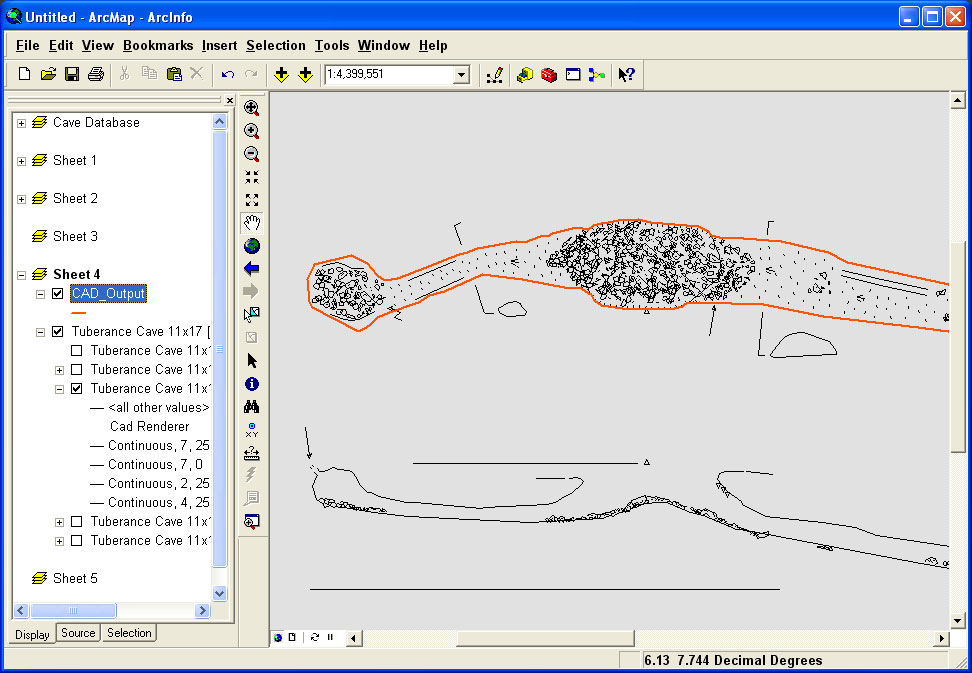
ILLUSTRATOR EXPORT TO ARCGIS
Another option for bringing your Illustrator (or other drawing program) maps into ArcGIS is by exporting to a CAD format - either DXF or DWG - and using those directly as layers in ArcGIS. From there additional manipulation can be performed to organize and separate various drawing layers into GIS layers, add attributes, and further refine the data. Note that some entity types are not fully supported using versions of ArcGIS prior to 9.4 (not yet released), so you may have to manipulate or simplify the linework in the drawing prior to export.
There are some excellent examples of large-scale GIS cave data management and analysis that have been implemented using this workflow. See Hurricane Crawl Cave: A GIS-Based Cave Management Plan Analysis and Review (Despain and Fryer, 2002).
(Note: ongoing software development work at ESRI will facilitate this workflow - E-mail for additional information.)